Archaeologists unearth Aramingo Canal

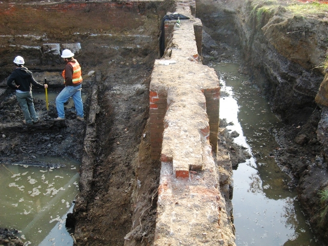
You can see the brick foundation of the Cramp Shipyard building in the photo. Also attached is the official press release, and a brief summary of investigations to date by Doug Mooney of URS.
By Kellie Patrick Gates
For PlanPhilly
Archaeologists working at the site of a new Girard Avenue ramp for I-95 have discovered the remains of an old means of transport: The 160-year-old Aramingo Canal.
Some of what’s been discovered is highly unusual. The sides of the canal are made of wood, said Doug Mooney, senior archaeologist with URS Corporation, Inc., the firm doing the work for the Pennsylvania Department of Transportation. Most of the time, canal sides were made from stone or earth, he said.
The rough-sawn logs, buried in wet earth, are extremely well preserved, Mooney said. “You can still see the places where the branches were cut off.”
The archaeology work is expected to continue through early December. Part of the effort will be to determine how the canal was constructed. And the team also wants to learn more about how the canal shaped Kensington.
“Philadelphia was the premier industrial city in the development of the United States, and it is an important part of that development,” said PennDOT District Six Cultural Resource Professional Cathy Spohn, who is also an archaeologist.
Said Mooney: “There’s not a great deal known about it, historically, largely because it wasn’t successful.”
The Aramingo was an attempt at economic revitalization, 19th Century style.
“The canal was the brainstorm of a group of people who owned property along a natural stream called Gunnar’s Run,” Mooney said. (Gunnar is the proper original spelling, as the stream was named for an early Swedish settler, Gunnar Rambo, Mooney noted. But the area was known for good fishing and hunting, and so some people began to spell it “Gunners Run”)
The 52 property owners who incorporated the Gunner’s Run Improvement Company in 1847 hoped that “canalizing” the slow-running, un-navigable stream would allow boats to take goods from their neighborhood out to the Delaware and beyond, thus revving up economic development. Congress declared the canal an official highway in 1856.
“For a time, it seems to have done the trick. It spring-boarded the creation of prominent businesses along the canal,” Mooney said. Among the industries that used the canal: The Lewis White Lead Works, the Leibrandt & McDowell Stove Works, the Gillingham & Garrison and Brown & Woelpper Saw and Planing Mills, the Hughes & Patterson Rolling Mill, and the Dyottville Glass Works.
But the canal was never what its creators hoped it would be, and it eventually failed altogether.
The canal was supposed to stretch 5.5 miles out from the Delaware, Mooney said. “I don’t think it ever was built beyond Tioga Street,” he said. Canal users were supposed to pay subscription dues for construction and maintenance, but much of the money never came in.
Compounding the canal’s problems was the development it had helped to spur. The industries dumped their waste into it, and the flow of the water was not enough to take what was dumped in out to the river. The flow slowed even more. “In 1884, the Philadelphia Water Department described it as an open sewer clogged with filth,” Mooney said. And newspaper reports from the time said the water was ink-black and smelled horrible. City officials blamed the Aramingo Canal for outbreaks of typhoid fever and malaria.
“It became a diabolical place,” Mooney said. And so the city started to drain it and fill it in, sometimes adding sewers before covering it. By 1895, the canal only extended to Norris Street – the location where URS Corporation and PennDOT are now working. By 1902, the canal was completely drained and covered over.
Mooney’s team first discovered remains of the canal in 2007. URS immediately wanted to learn more, but the area where they discovered the west wall did not allow for much work space. The current site is 100 feet to the east – the eastern wall of the canal.
Digging yielded a surprise: The massive brick foundations from one of the Cramp Shipyard buildings. The foundation is at a higher level, so that when one stands on its walls and looks down, the east wall of the canal is within and beneath the foundation, Mooney said.
PennDOT’s Spohn said the canal has been determined worthy of the National Register of Historic Places. PennDOT will not spend the time and money to nominate it, she said, but it will treat any information or artifacts gleaned from the on-going work according to National Register guidelines.
It is possible that some sort of plaque will be placed at the site, she said.
Any history learned about the canal’s construction and its impact on the community will be compiled in report for the Pennsylvania Historical and Museum Commission, she said, and it’s likely that some sort of document will also be produced for the general public. There’s also the possibility of a video.
As for the wooden pieces of the walls themselves, they are likely to be reburied on site after the study concludes, Spohn said. “If that wood dries out it would be destroyed,” she said. The reburied wood should remain as well-preserved as it is now, she said, and in the future, new technologies or techniques might reveal more information from it.
The overpass’s piers won’t pierce through the site, she said.
PennDOT is willing to arrange tours for anyone interested in seeing what’s happening around the old canal and shipyard, she said. Those interested should call Spohn at 610-205-6711.
Posted by Kellie Patrick Gates
WHYY is your source for fact-based, in-depth journalism and information. As a nonprofit organization, we rely on financial support from readers like you. Please give today.


