


Proposed park over I-95 and Columbus Blvd. easy to build, hard to fund

Building an eight-acre park over I-95 and Columbus Boulevard from Walnut to Chestnut streets would not be too complicated a task for engineers and construction crews, say two PennDOT experts.
“Whether it carries a park or whether it carries trucks, it’s still a bridge,” said Elaine Elbich, PennDOT District 6 project manager.
District 6 Engineer in Charge of Design Chuck Davies doesn’t think the Delaware River Waterfront Corporation would have much trouble getting a permit to build the structure that would allow people to walk from Front Street to the riverfront or hang out in-between, either.
But getting federal transportation money to help pay for a project likely to cost hundreds of millions of dollars? That, said Davies and Elbich, is where things would get difficult.
“Justifying the expense of transportation dollars for the highway’s effect on the waterfront is going to be the central task,” Davies said. “It’s really describing a problem that is in very few locations in the country, and it’s a problem that doesn’t have a name, this separation from the waterfront. It’s not commonly recognized as being a problem that requires mitigations.”
If it ain’t broke, the feds won’t fix it
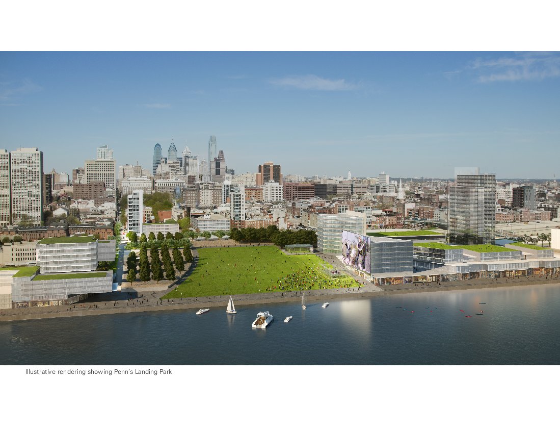
There is currently a partial cap, bearing a park, over I-95. The Central Delaware Master Plan calls for a cap that is significantly bigger, so that it reaches the whole way from Walnut to Chestnut streets and from Front Street to the river at Penn’s Landing.
Federal funding for local projects on I-95 is funneled through PennDOT. The federal government is not going to provide transportation funds to replace the partial cap until that cap needs to be replaced, Davies said. “It does have to be a generally recognized necessity in the public’s interest,” he said. The current structure would have to “no longer be serviceable or safe, or deteriorating.”
When will it be this part of the highway’s turn for repair and replacement? “If we split up all 51 miles of I-95 (in the district), this is the actual last piece,” Elbich said.
“We are talking decades, plural,” added Davies. “Mid-century.”
The Master Plan has a different time line, but more details are in the works
The Central Delaware Master Plan calls for the Penn’s Landing project, which also includes an extension of the South Street pedestrian bridge and other elements, to happen within 10 to 15 years, said Karen Thompson, planner/project manager at Delaware River Waterfront Corporation. DRWC is the quasi-city agency which oversaw creation of the city’s waterfront plan and manages its waterfront property.
But it’s not yet known whether the existing highway cap would need to come down to make way for the proposed project, or if the old structure could be incorporated into a new one, she said.
That’s one of many questions that will be answered by the engineering and design consultants DRWC is looking to hire. Their search began with a recently posted request for qualifications, and Thompson hopes the board will choose the team in April.
The consultant will also be asked to break the Penn’s Landing project into phases, and to determine the cost of each phase, she said. So it may be that the project is done gradually over time.
Thompson said DRWC won’t work on a funding strategy before it knows how the project would physically be done, how much it would cost, how it could be phased, and other information. But “we never thought it would be easy to get federal dollars,” she said.
If the partial cap does not have to be torn down, federal money could be sought to build more structure and make improvements, Davies said. But that also seems unlikely, given that highway infrastructure across the country is wearing out. “Transportation dollars would have to be in tremendously plentiful supply,” he said. “It’s so hard to imagine a situation (where the federal government) would say ‘Let’s put a couple of hundred million dollars down there and make it real nice,’” he said.
As stated earlier, the cost estimate for this project isn’t in yet. But for comparison, the much-smaller I-95 bridge over Vine Street cost $110 million.
While it’s uncertain where money for the project will come from, Thompson said DRWC never thought it would be a single source. “We just assumed the funding would come from a huge variety of sources,” she said. “It depends on the timing, when this can happen, and what’s available at that time.”
Davies and Elbich said it is conceivable that the federal government would contribute some money toward a project that was also funded through other sources, but they’ve never seen a project of this magnitude with a hybrid funding structure in this area.
If DRWC waits until the current cap is scheduled for replacement, it would still have to justify additional federal spending for a larger structure. In this scenario, Davies is more optimistic.
“I think it would have a good shot,” Davies said. If the old structure had to go, anyway, the new approach is “measured, and a treatment that has a lot to say for itself,” he said. “It’s hard not to like it.”
Davies and Elbich have talked with DRWC about the overall concept of this project already, when the Master Plan was being assembled.
The project is designed to help mitigate the current impact of the highway by re-connecting the city to its waterfront. Davies noted that there have been years of discussion about this locally, but the trick will be proving to those in charge of the federal money that there really is a connectivity problem.
The master plan itself notes that there are many streets that already lead to the waterfront, and those are visible on the map. “It’s going to take a lot of talent to articulate these justifications, but personally, I can see it,” Davies said.
Without federal funds
If the DRWC raised the money to pay for this project elsewhere, what they would need “is a glorified highway occupancy permit,” Elbich said.
Such permits are common, and are needed for things like building a shopping complex with a driveway on a state road, she said.
Elbich said at its center pier, the bridge that carries the Ben Franklin Parkway over Vine Street is about 500 feet in length, about the same as the park being contemplated. It requires lights on the roadway, and those would be necessary here as well. But the distance does not require fans and ventilation, and this wouldn’t either.
Davies noted the rough draft of the project within the Central Delaware Master Plan doesn’t show any curves or other exotic configurations.
Although this cap would be bigger than the existing one, it is not a new concept, they noted.
Still, the project is significantly more complicated than a driveway, and PennDOT would spend more time – likely many months worth – working through the details of the proposal and ironing out any potential problems with DRWC ahead of time, Davies said.
Elbich also noted there would have to be a separate discussion about who would ultimately own the resulting structure – the DRWC/city or PennDOT.
Either through the state’s process or the federally one required for funding, DRWC would have to do studies on traffic, light pollution, storm water runoff, air quality.
But both Elbich and Davies predicted DRWC would ultimately get the occupancy permit.
Thompson brightened when told that Elbich and Davies thought an occupancy permit would likely be attainable. “I’ll hold them to that!” she said.
WHYY is your source for fact-based, in-depth journalism and information. As a nonprofit organization, we rely on financial support from readers like you. Please give today.
Brought to you by PlanPhilly

PlanPhilly
In-depth, original reporting on housing, transportation, and development.
")
Philly remains a city of homeowners amid sharp drop in residential property sales
Pew’s latest “State of the City” report shows the homeownership rate is still above 50% even as an inventory crisis crunches the housing market.
2 weeks ago
Listen 0:49
‘We’ve been waiting’: Case over control of the Germantown Y is underway
The city selected a developer to revamp the YWCA seven years ago, but the property remains vacant and crumbling. A judge could change that.
1 month ago

New rules aim to boost EV sales as Philly drivers await more charging stations
A federal program to help states install charging stations has met a slow rollout, leaving EV drivers dependent on the available slower chargers.
1 month ago
Listen 2:00