Recommendations made for key North Delaware brownfields sites

The former Philadelphia Coke Co. site in Bridesburg should be redeveloped as a mix of industrial, commercial, residential, and open-space uses, a new report concludes.
The site, a 67-acre parcel that’s been vacant since the 1980s, has been subject to a variety of proposals over the last several years. In 2007, the site was rezoned from its industrial classification to an experimental waterfront residential category in anticipation of a huge project proposed by developer John Westrum, which never got off the ground. Then in 2013, Councilman Bobby Henon proposed changing the zoning back in hopes of luring a new industrial tenant to the site. Neighbors balked at that plan, and Henon dropped the bill while promising to keep trying to generate interest in the parcel, which is currently owned by National Grid and is known to Bridesburg residents as “Cokies.”
Later, while the city was working to convince the lunchmeat manufacturer Dietz & Watson to expand its Northeast Philly headquarters, the Philadelphia Industrial Development Corporation (PIDC) gave up control of a small waterfront parcel adjacent to the Coke site to the public. That parcel is now under design for a future park that will link up with the Delaware Waterfront trail.
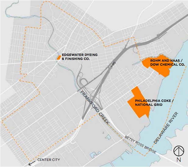
The latest proposal comes as part of the Frankford Creek Watersheds Brownfields Area-Wide Plan, which was developed over the last year and funded by a grant from the Environmental Protection Agency.
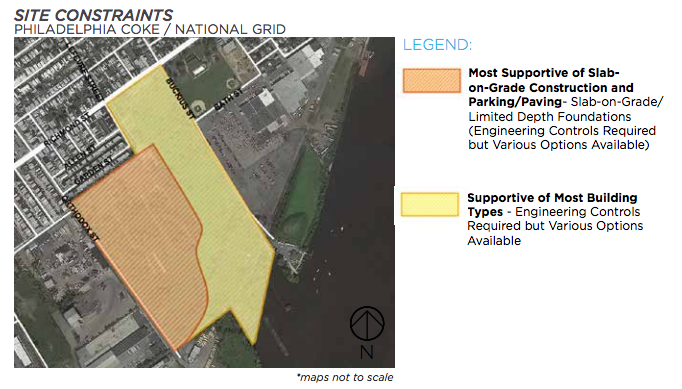
The plan, which is conceptual and non-binding, calls for the site to be split up to serve various neighborhood goals. It calls for reusing 32 acres in the center of the site for industry, leaving 27 acres of open space, and building a small amount of residential and commercial space on the western portion of the property, facing the surrounding neighborhoods.
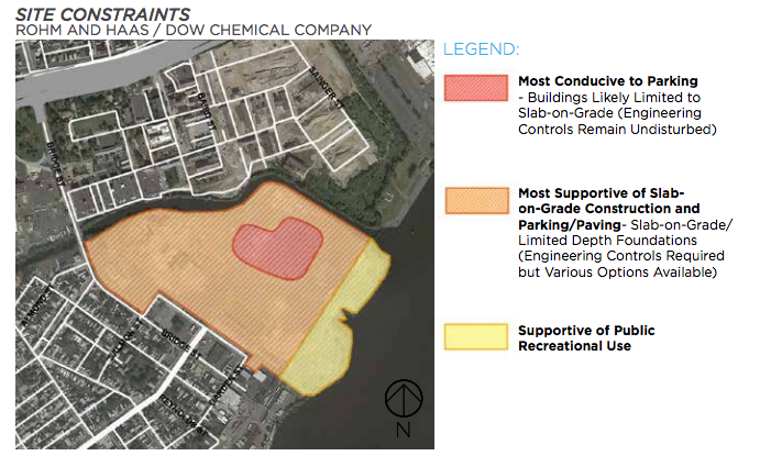
The Coke property is one of three “catalyst sites” that were the focus of the brownfields plan. The final report calls for a similar division of uses at a former Rohm and Haas/Dow Chemical site to the north of the Coke property. That 68-acre industrial property has been out of use since 2010, and the report calls for 21 acres of industrial redevelopment, 30 acres of open space, 10 acres of dedicated stormwater management space, and half an acre for commercial development.
The plan also calls for the implementation of the Frankford Creek Greenway, to transform the upper reaches of Frankford Creek into a public amenity.
The City received a $200,000 grant from the EPA in May of 2013 to conduct a study of the area. The city then contracted with Stromberg/Garrigan & Associates to carry out the plan through civic engagement and market studies. The study focuses on brownfields, areas where development is inhibited by real or perceived environmental issues. The Coke site, for example, was used for processing coal, which contaminated the soil.
The area covered by the plan overlaps with two Philadelphia2035 planning areas: the Lower Northeast District and the North Delaware. A plan for the Lower Northeast was adopted by the Philadelphia City Planning Commission in 2012. The Commission is now at work on a plan for the North Delaware, which involves dealing with a host of industrial waterfront properties.
WHYY is your source for fact-based, in-depth journalism and information. As a nonprofit organization, we rely on financial support from readers like you. Please give today.


