


Lower Southwest District Plan adopted by commission

The Philadelphia City Planning Commission voted unanimously on Tuesday to adopt the Lower Southwest District Plan–the 12th of 18 District Plans to be completed as part of the city’s Philadelphia 2035 comprehensive planning initiative.
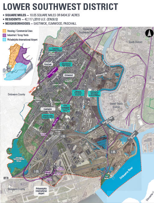
The Lower Southwest District encompasses the area commonly referred to as Southwest Philadelphia and includes the neighborhoods of Eastwick, Paschall, and Elmwood; significant industrial zones; and the Philadelphia International Airport. It is bounded by Cobbs Creek to the west, the airport to the south, the Schuylkill River to the east, and 58th Street and Mount Moriah cemetery to the north.
It’s an area that’s been largely untouched by the city’s rebounding housing market, where vacancy has risen and property values dropped despite an influx of new immigrants, particularly from West African and Southeast Asian countries.
Among the neighborhood’s assets are planned or existing recreation trails, like Cobbs Creek, the Heinz Wildlife Refuge, Fort Mifflin, Bartram’s Garden, and an improving Schuylkill River. But planners note physical barriers, including industrial land use and train tracks, separate neighbors from these assets. The same features that make it an attractive location for oil refineries, a U.S. Postal Service distribution center, and tenants of the Eastwick Industrial Park are often in conflict with residential quality of life.
Lower Southwest’s biggest issues going forward are airport expansion, environmental challenges and flooding, meeting the demand for industrial land, stabilizing residential neighborhoods, and increasing access to the Schuylkill River waterfront.
At Tuesday’s Planning Commission meeting, Martine Decamp, the University City and Southwest planner, presented the Commission with an overview of the Lower Southwest plan’s high-level goals and the public feedback that informed them.
The public outreach for the plan included three steering committee meetings attended by community groups, non-profits, city agencies, and elected officials, as well as three public meetings attended by 268 community members. It then underwent a 30-day comment period, the feedback from which was incorporated into the final draft presented for approval on Tuesday.
A new future for large vacant tracts
Many residents have spent the last 60 years struggling with an unaccountable land use regime. In 1957, the city condemned around 2,000 acres of private property in Eastwick, then known as the Meadows, and evicted over 8,500 people from their homes to make way for an urban renewal plan that largely didn’t pan out.
Since 1961, more than 100 acres of land in Eastwick was controlled by the Korman Company, as the result of a redevelopment deal with the Philadelphia Redevelopment Authority. Last year, the city finally bought back the land, and a community planning process for this property will commence following a flood assessment.
A large percentage of the public comments on the plan asked the city to remove the designation of blight certification, which allowed for the original seizure of land in Eastwick, but Decamp explained the city doesn’t have the power to do this.
“We currently have a recommendation in the plan to revise the blight designation, and to revise the Redevelopment Area Plan, however there is no mechanism at the state level for us to be able to remove the designation of blight,” she said, “The blight designation further gives PRA a tool to deal with redevelopment, but again, we don’t have the authority to remove the designation.”
One of the main objectives in the plan is to document all of PRA’s land holdings in the area for conveyance, with the goal of repurposing many of the large vacant parcels in the district. A few specific parcels singled out in the plan include the former GE site at 70th and Elmwood, the former Pepper School at 84th Street and Lindbergh Boulevard, and the 128-acre Korman site south of 84th Street.
The plan also has recommendations to make the industrial tenants better neighbors. Those include developing more energy-efficient and environmentally-sensitive industrial facilities, and conducting further research on best practices particularly for large scrap facilities.
“There are a lot of impacts that this has on the neighborhood, so we’d like to make sure that this operation functions the best that it can within the district,” said Decamp.
One of the more popular public requests resulting in changes to the plan included an expansion of the recommendations for supporting existing commercial corridors like Woodland Avenue. The Commerce Department is interested in bringing together the disparate groups in the Lower Southwest to discuss a common vision for the area around Woodland Avenue, which has grown as a hub for new immigrants, Decamp said.
There was also strong support for co-locating public facilities so that city services are more easily accessible. Decamp pointed to Penrose Plaza as a location with high vacancy that could potentially serve this role.
Improving Mobility and Connections
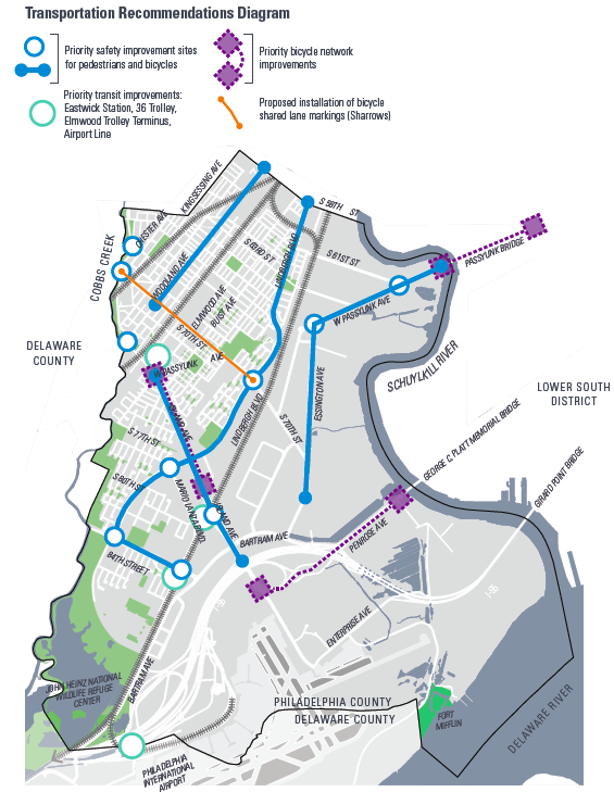
The plan has major recommendations to improve transportation, adding transit connections and making streets safer, within and through the district
The plan calls out a few of the more problematic patterns in the Lower Southwest’s disjointed street network: “There are walkable commercial corridors with wide sidewalks; industrial arterials with narrow, obstructed, or no sidewalks; bridge approaches; highway interchanges to I-95 with uncontrolled on and off ramps; suburban-style residential roadways; and low-volume neighborhood streets with dense development.”
Eastwick has many disconnected streets with cul-de-sacs so planners suggest knitting the street grid together. Completing the trail connections, planning for underutilized open spaces, and calming vehicle traffic on key corridors were mentioned as ways to enhance mobility within the district and improve connections to surrounding areas.
Transit recommendations center on improved infrastructure and more functional connections. The plan calls for the creation of a new Eastwick Transportation Center at the Eastwick Regional Rail Station, which could be a focal point for development. It also includes timely prescriptions for trolley modernization and airport capacity enhancement.
SEPTA operates three trolley routes within the district— the 11, 13 and 36—all of which will see improvements under the trolley modernization plan. The Route 36 has the highest ridership, and it stops just three blocks away from the Eastwick regional rail station. Planners recommend closing that gap, extending the 36 trolley a further three blocks to share a new transportation center at Eastwick Station.
An extension of the 36 to the airport might also be warranted as part of PHL’s Capacity Enhancement Program and proposed people mover project.
All three trolley routes are in line for Transit Signal Prioritization and ADA accessible streetscape changes, which are expected to result in faster speeds and more efficient boarding, as well as improved pedestrian safety and streetscape appearance, according to the plan.
Trolley modernization will also require an expanded surface transportation depot in addition to the Elmwood Depot, to house the new larger trolley vehicles. The Woodland/Elmwood Avenues Focus Area of the plan suggests the former GE site on Elmwood Avenue as a possible location for this.
Decamp said feedback from SEPTA led to changes in the recommendations for airport transit improvements.
“SEPTA would like to construct a new crossover switch at the Airport Terminal stations to allow full use of both tracks, because they believe that’s one of the best ways to improve service to the airport,” she explained.
Following Decamp’s presentation, Planning Commission members did not raise any questions or concerns, and voted unanimously to adopt the plan.
A final version of the plan will be available online by the end of the day Wednesday.
WHYY is your source for fact-based, in-depth journalism and information. As a nonprofit organization, we rely on financial support from readers like you. Please give today.
Brought to you by PlanPhilly

PlanPhilly
In-depth, original reporting on housing, transportation, and development.

A levee could be built in flood-prone Eastwick. Delaware County has concerns
The city of Philadelphia will not move forward with the project unless negative impacts on Delaware County are addressed, an official said.
5 months ago
Listen 1:03
‘We want to know, what are you doing?’: Eastwick residents question officials on proposed levee
Residents of a flood-prone Philly neighborhood learned more about a proposed 15-foot levee near their homes during a meeting Wednesday.
7 months ago
A 1,400-foot levee could be built in Eastwick. Here’s what you need to know
In a long-awaited study, the U.S. Army Corps of Engineers recommended the levee to reduce flooding in the low-lying Philly neighborhood.
7 months ago