


Exploring the Lower Schuylkill’s gritty and green potential

The Lower Schuylkill is hard to get to know much less love. It’s a nearly 4,000-acre area comprised of largely industrial and underused property, wrapped with tricky rail and road crossings, and there are precious few places to get close to the Schuylkill itself.
But there is renewed interest in this part of Southwest Philadelphia as the city considers what kind of industrial development could be added in the coming decades. The Philadelphia Industrial Development Corporation and Planning Commission, and Commerce Department are jointly developing a Master Plan for the Lower Schuylkill geared at creating new economic, industrial, and recreational opportunities.
The Lower Schuylkill has the city’s largest concentration of industrially zoned properties and is near two of the city’s biggest economic hubs: the Navy Yard and University City. Among the big planning questions: How can the city help position the Lower Schuylkill as a 21st century economic engine? Are there opportunities to reclaim underused parcels and river frontage for new recreation trails and amenities?
All of this Lower Schuylkill talk got me wondering: What’s actually there? I went looking.
On a recent afternoon I set out to explore the Lower Schuylkill study area with Andrew Goodman, a planner with PennPraxis (a consultant on the Master Plan), as my guide.
We traversed the Lower Schuylkill from Forgotten Bottom to the lost landscape below the Platt Bridge and back again. We stood on the Passyunk Avenue Bridge and took in the vista (and fumes) from the PGW and Sunoco lands, and we visited pockets of green at Common Ground Garden by the airport and along the Gray’s Ferry Crescent. We saw places where the sidewalk ends and the grid disappears. We poked around the many rail lines and peeked into old industrial buildings.
At the northern end of the study area the parcels are smaller, more fragmented, and the landscape bears the record of old industrial uses clustered and oriented toward the river, mixed in with special sites like the Woodlands or Bartram’s Garden. As you head south the river becomes less accessible, something to cross instead of experience. The parcels get bigger. Larger residential areas like Eastwick dip down into otherwise anonymous expanses of suburban-style office and industrial parks near auto retail and the Food Distribution Center. And then there is everything we need but don’t know where else to put: The Least Restrictive Zoning World where scrap yards and strip clubs set up next door to one another; waste treatment facilities; a lonely tugboat operator.
It’s a big, complicated place. But it also represents an extraordinary set of economic and environmental opportunities for the city. Here are four observations about the future of the Lower Schuylkill based on what I saw on the ground:
Seeing growth through the grit
The area just south of University Avenue, from University City to Bartram’s Garden, is peppered with smaller parcels, older industrial buildings and residential pockets on both sides of the river. And it’s here that the potential for a new, productive future is easiest to imagine.
We often hear that our city’s “Meds and Eds” are the drivers of our economy, and today’s research is tomorrow’s startup. But University City’s institutions (Penn, Drexel, Wistar, Science Center, University of the Sciences, etc.) are space-constrained. That means it’s difficult to for researchers and inventors to scale up new innovations from the institutional setting through early product development and manufacturing. It’s in the city’s interest to keep that creative, economic power here and it’s in the startup’s interest to stay close to institutional brainpower. The Lower Schuylkill’s got a lot of underused industrial properties – from labs to factories – that could become institutionally supported incubators or cheap startup space.
On the eastern side (aka South shore) Penn’s acquisition of DuPont’s Marshall Labs offers a preview of what this incubator future could look like. There are plenty of properties, some publicly held, waiting for new uses. The Streets Department property along Gray’s Avenue at 50th Street is one such example. Maybe even the former MAB Paint factory on Gray’s Avenue at 52nd Street. If Streets opts to leave its sprawling property stretching to the river, and the MAB factory doesn’t become a reentry facility, these properties provide a lot of space for productive new enterprises.
Here are a few old industrial properties along Gray’s Avenue:
Industrial legacy and the long view
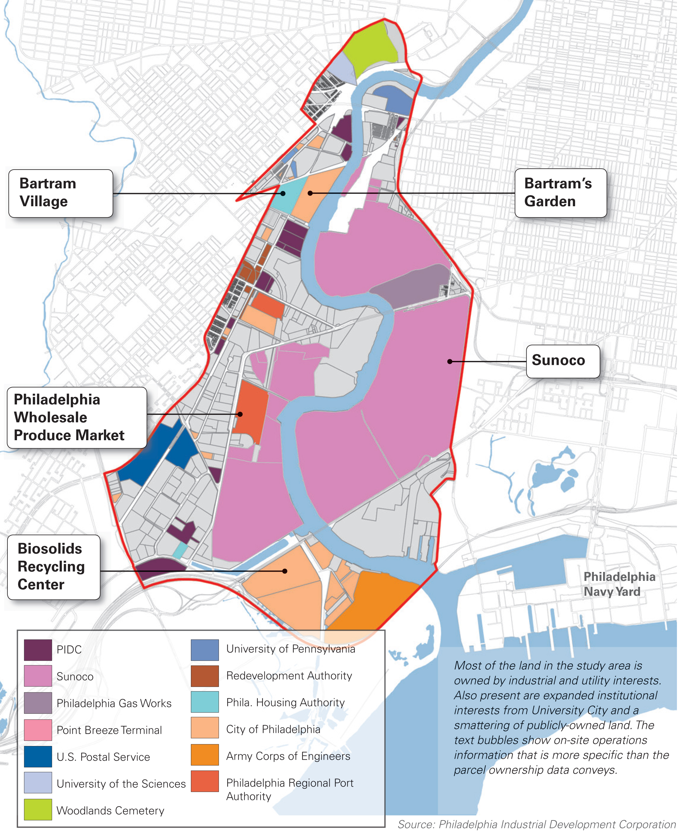
The Passyunk Avenue Bridge is a tall, treacherous highway-style drawbridge that bounces as the steady stream of semi trucks speed past. It’s a hostile sensory experience, topped off with a skyline view. The air is so thick with fumes that you can taste it. But we walked over the bridge to take in the scenery. To the south is Sunoco’s huge Philadelphia refinery and the sparse PGW yard stretches northward. There’s a maze of pipelines, and washes of green on ex-industrial land. The soft and lazy Schuylkill runs through it all.
Sunoco is the biggest private landowner in the Lower Schuylkill. And even though refining has taken place along the Schuylkill’s banks since the Civil War era, we don’t know what the future holds for the Sunoco site. Sunoco says unless a buyer is secured for its property, the Philadelphia refinery will close on July 1. Evidently there are interested buyers.
Given the uncertainty of refining’s future on the Lower Schuylkill, maybe a new future for this landscape will come into focus sonner than later. At the very least, as Sunoco changes hands pieces of its holdings should be reserved for major industrial development, hopefully with a greener future in mind than the area’s historic oil refining operations. Others might be more appropriate for green infrastructure or recreational uses.
Here are views from the Passyunk Avenue Bridge and its environs:
Remediation and Recreation unite
Peppered throughout the Lower Schuylkill area are beautiful pockets of green, but not nearly enough. Spots like the Common Ground community garden near the airport, the Woodlands, and Bartram’s Garden are real recreational, environmental, and community assets, but these are few and far between.
Everywhere you look the legacy of production and industry loom large, and the amount of remediation that must be necessary on many of these parcels boggles the mind. Here’s where I see the huge potential for large-scale green infrastructure, bioremediation, wetlands restoration and recreational space that could provide public amenities while cleaning the environment. What if part of Sunoco’s holdings became a sponge/scrubber landscape, designed to repair the damaged environment? Much of the Lower Schuylkill probably cannot be developed because of marshy soil. These areas could be eco-parks and remediators all in one.
The Water Department is already working to combat the extraordinary amount of hard, impervious surface with tree trenches and stormwater bumpouts at some of the most forlorn intersections. But there’s a long way to go when it comes to greening this part of the city. As large parcels change hands the city should work to secure appropriate sites for green infrastructure work to help remediate pollution and runoff. The parcel on the southwest side of the river below the Passyunk Avenue Bridge comes to mind.
The new Gray’s Ferry Crescent section of the Schuylkill Banks trail is a graceful, but isolated, preview of what a riverfront trail network might look like stretching south. When DuPont left the Marshall Labs, the Schuylkill River Development Corporation remediated the polluted soil, planted the riverfront park, and created a greenway trail.
Today it’s a green strand perfect for getting near the river (though you can’t get too close), and shows that environmental and recreational benefits make a wonderful team in the Lower Schuylkill. During our visit crews were busy sprucing up the trail for the season and two guys were fishing away their afternoon. Hopefully the Gray’s Ferry Crescent will link up with the rest of the trail network.
Here’s a look at the crescent:
Critical Connectivity
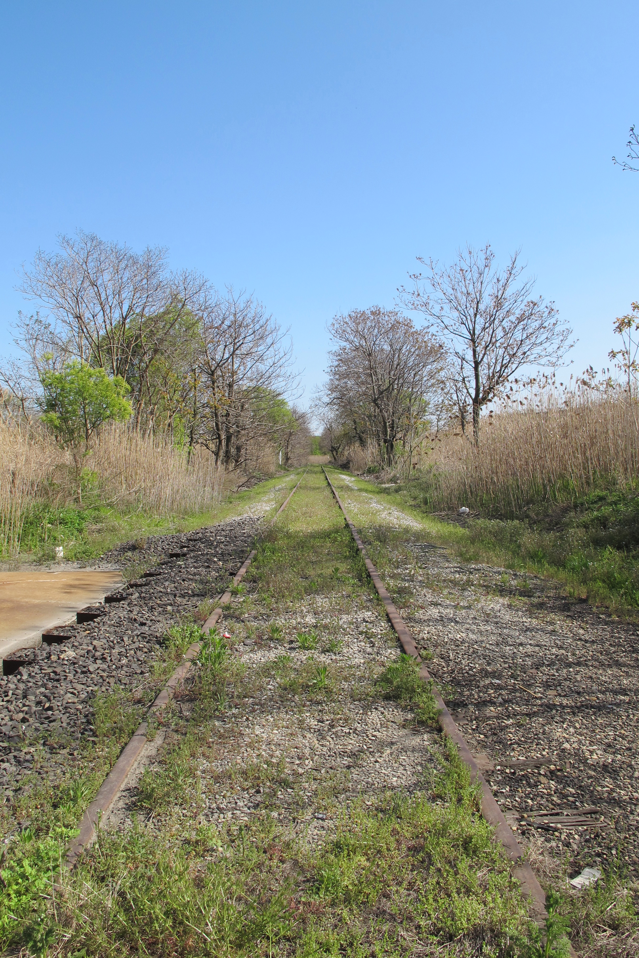
In terms of transportation the Lower Schuylkill has it all. Buses traverse the district and trolleys are frequent, and there is ample freight rail, airport, and highway access. But the area’s rail and highway infrastructure are a complete tangle that will complicate as well as complement any future development plans.
On our explorations I lost count of how many rail crossings we made. We peeked at the CSX Eastside yard and we witnessed one of the strange bottlenecks along the Airport Line.
SEPTA’s Airport Line, the 36 Trolley, CSX and Norfolk-Southern freight lines, and Amtrak all crisscross the area. There are points where expanded passenger rail service would be difficult to fit in, but there are also abandoned rail rights of way, like the 60th Street rail corridor, that could make for trails or future SEPTA or freight spurs. For now it’s a maze that also limits access to the riverside.
Any transformation of the Lower Schuylkill will not happen over night, but the time to plan its future is now. There’s ample room for well-planned industrial development, innovation clusters, as well as public space along the river for recreation and trails that can repair environmental damage as well as create public amenities where there are few. The possibilities are as vast as the landscape itself.
If you want to learn more about the Master Plan and share your thoughts about the Lower Schuylkill, there’s no time like the present. Head out to one of the two public meetings this week – Wednesday at Richard Allen Charter School (2601 S. 58th Street) or Thursday at Marshall Labs (3401 Grays Ferry Avenue) from 5:30-7:30.
WHYY is your source for fact-based, in-depth journalism and information. As a nonprofit organization, we rely on financial support from readers like you. Please give today.
Brought to you by PlanPhilly

PlanPhilly
In-depth, original reporting on housing, transportation, and development.
Part of the series

Eyes on the Street
Eyes on the Street brings new ideas and fresh voices into the conversation about Philadelphia’s changing cityscape.
