


Could the dank underbelly of the El be Philly’s next great public space?

The recent spate of interest in repurposing Center City alleys as better public spaces has us thinking about which other underutilized spaces in Philly could use a touch-up, so it was fitting that the main event at this year’s Corridor Realities panel, presented by the Commerce Department and the Community Design Collaborative at DesignPhiladelphia, was a presentation from the Design Trust for Public Space about bringing some cheer to some of New York City’s most dismal spaces.
The Design Trust is a NY-based organization best known for producing the 2002 report that stoked interest in redeveloping NYC’s High Line into a public park. More recently they’ve been working on a project called Under the Elevated, which takes up the substantially more daunting challenge of enlivening the dead zones underneath elevated rail and highway infrastructure.
New York City has about 700 miles of elevated rail infrastructure that’s mostly concentrated in under-served communities and the outer boroughs, and the effect of this infrastructure is to render the spaces underneath dark and dreary. Picture the space under the El in Kensington.
Improbable as it might seem today, DTPS thinks this 700 miles can be cultivated as a resource, and this summer they built pop-up installations to demonstrate possible solutions.
Some simply created new public seating or recreation space, while others provided entertainment or some functional community resource. One was the Boogie Down Booth near the Freeman Street station in the Bronx, which plays music by Bronx artists. Another was a community-generated events calendar and bulletin board under the Manhattan Bridge in Chinatown, which the group envisions as a new gateway to Division Street. (You can read all about the project on their website, and they also sell a beautiful photo book reviewing the findings from these projects.)
Their next step is to develop an asset inventory of spaces most prime for place make-overs, using criteria like lighting, environmental and engineering conditions, architectural and historical characteristics, as well as policy factors like the DeBlasio administration’s Vision Zero initiative, which uses crash data and other metrics to prioritize corridors for traffic calming interventions.
Thinking about the applications for placemaking under the Market-Frankford El in Philly, I recalled one of the top pedestrian crash locations from our piece earlier this year: the area around Kensington and Lehigh Avenues in Councilwoman Maria Quiñones-Sánchez’s district:
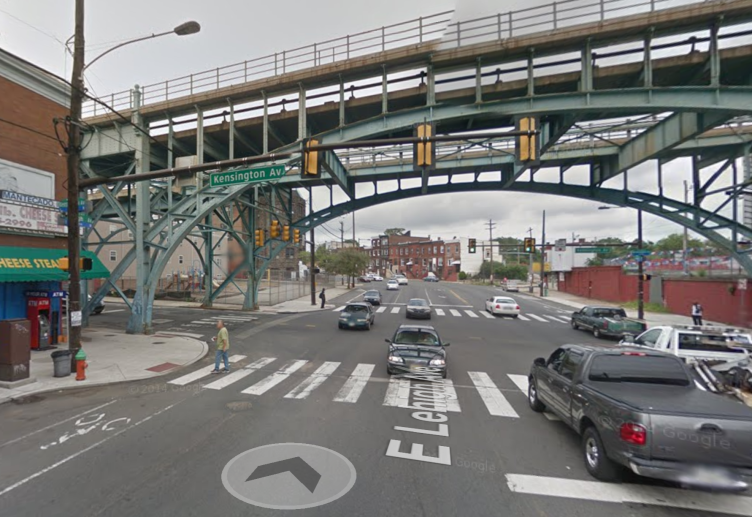
The intersections at Kensington and Lehigh (pictured) and Kensington and Allegheny are tied for the most dangerous crash locations in the 7th Council district, with 11 collisions each between 2008 and 2014. The intersection at Lehigh is on the border of the 1st and 7th Council Districts.
Both of these intersections are under the El, and if you look at Azavea’s crash map, you’ll see that areas underneath the El are generally problematic for pedestrian crossings throughout the region. Some of this owes to high foot traffic near rail stations, but the area under the El is also poorly lit and some of the intersecting streets feature wide travel lanes that promote speeding.
The New Kensington Community Development Corporation is aware of the issues and the potential at Kensington and Lehigh, and a few years ago they worked with Community Design Collaborative to produce some recommendations for corridor and pedestrian infrastructure improvements throughout the neighborhood.
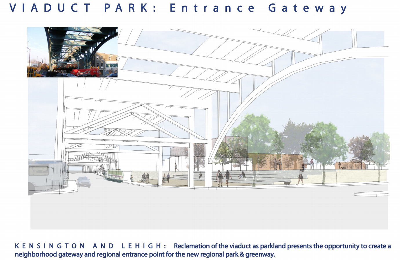
There’s a big vision for the Lehigh Viaduct as a greenway connecting residents of the area to public spaces along the Delaware River, and the intersection of Kensington and Lehigh is envisioned as the gateway to that trail. Specifically, they recommend removing the Strathman coal yard walls and creating a grand entrance to the trail from Lehigh:
Currently, the walls of the Strathman coal yard isolate the viaduct from Lehigh and Kensington Avenues. Removal of these structures presents the opportunity to re-imagine the intersection as a unique urban place and gateway to the park network. Opening the park to Lehigh Avenue and modifying the landscape to create a major park entrance will convert the dark congested intersection to a vibrant urban space, a space where recreational green-space collides with a busy urban neighborhood, dramatically highlighted by the historic bridge structure.
Here’s a sketch of what they have in mind:
This type of intervention would obviously be a lot more expensive and involved than the sort of light, quick, and cheap projects the Design Trust has been installing this summer, but community development advocates in the area might take a page from Under the Elevated to start sprucing things up in the near term, as a downpayment on long term change.
WHYY is your source for fact-based, in-depth journalism and information. As a nonprofit organization, we rely on financial support from readers like you. Please give today.
Brought to you by PlanPhilly

PlanPhilly
In-depth, original reporting on housing, transportation, and development.
Part of the series

Eyes on the Street
Eyes on the Street brings new ideas and fresh voices into the conversation about Philadelphia’s changing cityscape.

It’s time for Philadelphia to invest in solutions that will make our city’s public spaces safer, more equitable, and enjoyable for all, writes Ariel Ben-Amos.
2 years ago

Philly’s new tree bill is a great start to hold developers accountable. But it needs work
Philly’s new tree bill will create fees for developers who remove trees and don’t replace them, but the city needs to do more to increase our tree canopy.
2 years ago
What streeteries can teach us about reclaiming public space for people
The pandemic forced cities to rewrite the rules of the road and engage residents in the process.
3 years ago